Share
+ more Maine environmental news.
 ‌ ‌ ‌ ‌ ‌ ‌ ‌ ‌ ‌ ‌ ‌ ‌ ‌ ‌ ‌ ‌ ‌ ‌ ‌ ‌ ‌ ‌ ‌ ‌ ‌ ‌ ‌ ‌ ‌ ‌ ‌ ‌ ‌ ‌ ‌ ‌ ‌ ‌ ‌ ‌ ‌ ‌ ‌ ‌ ‌ ‌ ‌ ‌ ‌ ‌ ‌ ‌ ‌ ‌ ‌ ‌ ‌ ‌ ‌ ‌ ‌ ‌ ‌ ‌ ‌ ‌ ‌ ‌ ‌ ‌ ‌ ‌ ‌ ‌ ‌ ‌ ‌ ‌ ‌ ‌ ‌ ‌ ‌ ‌ ‌ ‌ ‌ ‌ ‌ ‌ ‌ ‌ ‌ ‌ ‌ ‌ ‌ ‌ ‌ ‌ ‌ ‌ ‌ ‌ ‌ ‌ ‌ ‌ ‌ ‌ ‌ ‌ ‌ ‌ ‌ ‌ ‌ ‌ ‌ ‌ ‌ ‌ ‌ ‌ ‌ ‌

View in browser   |   Forward

logo for the climate monitor newsletter
this edition was produced by julia tilton.

A pair of North Atlantic right whales in the Gulf of Maine in 2023. Researchers are tracking zooplankton to understand where the endangered whales are likely to feed. Photo by Robert F. Bukaty of the Associated Press, NOAA permit #21371.

What can we learn from zooplankton?


Karen Stamieszkin, a senior research scientist at Bigelow Laboratory for Ocean Sciences, was out on the Gulf of Maine three years ago when she saw red pooling in different directions beneath the waves: a large spring bloom of plankton.


“You could see these plumes of this fat, rich copepod population right at the surface,” said Stamieszkin, referring to a type of tiny crustacean. “That is what drives the Gulf of Maine’s iconic fisheries.”


She was looking at masses of an organism that plays a central role in the Gulf of Maine’s ecosystem, eating plant-like plankton and then transferring that energy up the food chain, fueling the region’s cod, herring and tuna populations. 


Ask an ocean researcher why they study these zooplankton, and there are plenty of reasons. The tiny drifting sea creatures are found across the planet, where they play a key role in marine food webs and carbon sequestration. In the Gulf of Maine, studying zooplankton offers clues on the whereabouts of the endangered North Atlantic right whale, helping to improve conservation efforts and reduce collisions with boat traffic, and informs scientists’ understanding of climate change as the waters warm.


One species, Calanus finmarchicus, is particularly abundant. They are a primary food source for the North Atlantic right whale, of which there are approximately 380 remaining. 


Whales go where the food is, said Jérôme Pinti, a senior scientist at the Gulf of Maine Research Institute, and that is changing as the Gulf of Maine warms at one of the fastest rates in the world. 


The region’s warming waters mean that the organisms are increasingly shifting north, into colder waters that include the Gulf of St. Lawrence, and being replaced by smaller zooplankton that aren’t as fatty or appetizing to whales, Pinti said.

Two female Calanus finmarchicus. The one on the bottom has less fat because it was raised in warmer water. Courtesy of David Fields, Bigelow Laboratory for Ocean Sciences.

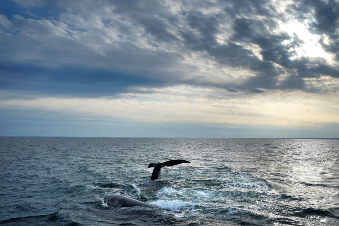
At Bigelow, Stamieszkin’s colleague Rebekah Shunmugapandi is working to model some of these consequences higher up the food chain. By using satellite imagery to map where copepods are most abundant at the water’s surfaces, Shunmugapandi can better determine where right whales may be moving to feed, both now and in the future.  


“When the right whale is following something, there's a high chance it should be Calanus, or the food it is trying to eat, so that's what I'm trying to predict based on the real-time data that we have,” Shunmugapandi said. 


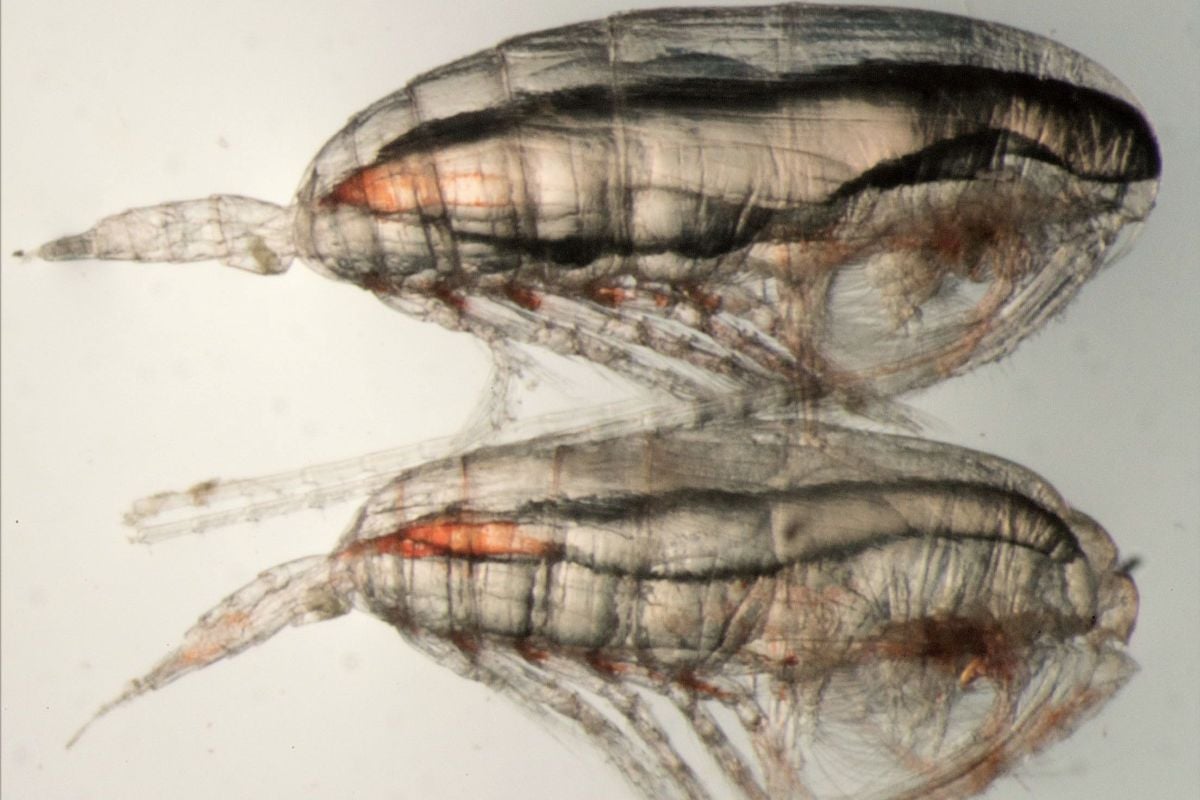
Historically, the cold-water Labrador Current has been one of the main ways that copepods arrive in the Gulf of Maine. But over the past few decades, scientists at Bigelow and the Gulf of Maine Research Institute have observed changes in the strength and intensity of the Labrador Current as water temperatures change. A cycle of accelerated marine warming occurred in the 2010s, delivering fewer copepods to the region as temperatures warmed. This, in turn, affected the feeding behavior of the right whale. 


Nick Record, a researcher at Bigelow who works with Stamieszkin and Shunmugapandi, remembers realizing that deep-water data — which is tied to the Labrador Current — had shown signs of the 2010 warming nearly two years before the surface-water data. 


“We didn't realize it was warming really rapidly until 2012… We were seeing surface temperatures that weren't supposed to happen until the year 2100,” Record said. “The right whale saw it two years earlier, because that subarctic current often enters the Gulf of Maine in deep subsurface waters that you can't see in the satellite data.”


Since then, Record has been paying more attention to deep-water data. Temperatures in the Gulf of Maine have cooled down since the marine heat wave of the 2010s, but Record said monitoring deep-water data could help researchers get an early understanding of potential shifts. 


“It's warming fast, but there are ups and downs on top of that. So right now, we're in a cold cycle, and probably things will bounce back at some point,” Record said. “It's hard to say when, but we can watch the deep water and get kind of like an early warning of when it's going to flip back.”

banner that reads "on our radar"

This piece from Smithsonian Magazine takes readers to the Falkland Islands, where scientists are studying how changing climate conditions are affecting rockhopper penguins.


As with the North Atlantic right whales, it is getting harder for them to find food as the oceans warm. 

banner ad for the Climate Work summit on March 19. Click the banner to learn more.
banner that reads "in other maine environmental news"

While The Maine Monitor does not place its content behind paywalls, some newsrooms we link to in this newsletter may. 

Maine makes progress towards recycling goal | Maine Public


Prolonged cold makes this one of Maine’s coldest winters in years | News Center Maine


What’s driving up Maine’s energy bills? Natural gas. | Canary Media


More Maine homeowners are ditching heating oil | Bangor Daily News


Maine Department of Transportation reverses course on replacing Machias Dike | The Maine Monitor


Conservation groups near $62M goal for 78,000 acres in western Maine | Sun Journal


Deer Isle group conserves land to help avoid downstream shellfish closures | Bangor Daily News


Protecting Newbury Neck Road from the sea will cost millions | Ellsworth American


Purchase of roadside spring in Woodstock saves water source from development | Bethel Citizen


Unity Environmental University launches school of business | MaineBiz


In photos: Smelt fishing returns to Cathance River in Bowdoinham | Morning Sentinel

Have feedback, a correction or know of something we should look into? Send it to our newsroom. You can also email The Monitor's editors: editors@themainemonitor.org.  


The Maine Monitor is a publication of the Maine Center for Public Interest Reporting, an independent and nonpartisan nonprofit news organization that produces investigative journalism. We believe news is a public good and keep our news free to access. We have no paywall and do not charge for our newsletters. If you value the reporting we do for Maine, please consider making a donation! We cannot do this reporting without your support.

DONATE NOW
banner that states the maine monitor is part of the trust project, an international consortium of news organizations implementing transparency standards. tap to learn about the monitor's editorial standards.

Manage preferences | Update email address


Email Marketing by ActiveCampaign