Share
+ more Maine environmental news.
 ‌ ‌ ‌ ‌ ‌ ‌ ‌ ‌ ‌ ‌ ‌ ‌ ‌ ‌ ‌ ‌ ‌ ‌ ‌ ‌ ‌ ‌ ‌ ‌ ‌ ‌ ‌ ‌ ‌ ‌ ‌ ‌ ‌ ‌ ‌ ‌ ‌ ‌ ‌ ‌ ‌ ‌ ‌ ‌ ‌ ‌ ‌ ‌ ‌ ‌ ‌ ‌ ‌ ‌ ‌ ‌ ‌ ‌ ‌ ‌ ‌ ‌ ‌ ‌ ‌ ‌ ‌ ‌ ‌ ‌ ‌ ‌ ‌ ‌ ‌ ‌ ‌ ‌ ‌ ‌ ‌ ‌ ‌ ‌ ‌ ‌ ‌ ‌ ‌ ‌ ‌ ‌ ‌ ‌ ‌ ‌ ‌ ‌ ‌ ‌ ‌ ‌ ‌ ‌ ‌ ‌ ‌ ‌ ‌ ‌ ‌ ‌ ‌ ‌ ‌ ‌ ‌ ‌ ‌ ‌ ‌ ‌ ‌ ‌ ‌ ‌

View in browser   |   Forward

logo for the climate monitor newsletter
this edition was produced by bridget huber.

Excavators spread sand dredged from the nearby harbor at the Webhannet salt marsh last winter, in a bid to save the sinking marsh and protect the birds that rely on it. Photo courtesy of Bri Benvenuti/Ducks Unlimited

Spreading sand to save a salt marsh


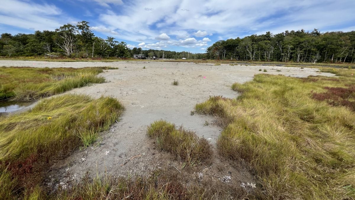
On a humid August morning, the Webhannet salt marsh in Wells was a sea of tousled, neon-green grass. But at the marsh’s northern edge, one spot stood out — about two acres of glittering white sand with only a few plants breaking through. Late last winter, excavators spread sand dredged from the nearby harbor there, in a bid to save the sinking marsh and protect the birds that rely on it.


The marsh is a test site for a type of restoration never before tried in Maine, known as the “beneficial use of dredged materials.” The method involves spreading a thin layer of sand and sediment to raise the marsh surface, helping it better withstand sea level rise and support birds like the endangered saltmarsh sparrow and black ducks. At this site, crews used 1,000 cubic yards of sand to raise the elevation by 3 to 6 inches.


At this time last year, this part of the marsh was much wetter. It flooded often and a large deep pool was expanding every year. 


“When it’s completely waterlogged all the time the peat starts to break apart,” said Bri Benvenuti, a regional biologist at Ducks Unlimited, which led the project in cooperation with a group of local and federal agencies and university researchers. “It gets really soggy and mucky and decomposes, essentially.”


The Webhannet marsh, like many others in Maine and along the East Coast, is drowning as sea levels rise. Marshes act like sponges, absorbing flood waters and storm surges, and buffering communities from storm damage, while providing habitat to many species. 


One of the reasons marshes are struggling to keep pace with climate change is because they are starved of sediment-like sand and mud. In an unaltered system, storms would wash up over barrier beaches and dunes, bringing sand onto the marsh.


This constant accumulation of sediment counteracts erosion, helping the marsh remain stable — which is even more critical as sea levels rise. But development — like roads, culverts and the strip of beachfront homes on Drakes Island beach has disrupted the process.


“Those dunes are largely non-existent now because they’re houses,” Benvenuti explained. “So the sand isn’t moving over those dunes at all.”


To mimic these processes, some scientists and conservationists in some parts of the country, particularly the Gulf Coast, have turned to the sand and sediment dredged from harbors and channels. While much of the material is dumped offshore or spread on beaches, it could be put to better use, Benvenuti said. “If we have this sediment that’s going to be pumped onto a beach or disposed of offshore, why can’t we put it onto a marsh instead?”


The idea isn’t quite as simple as it sounds. Getting the necessary permits took years, since this was the first project of its type in Maine. After dredging, the sand had to be tested for contaminants, and screened to remove debris.


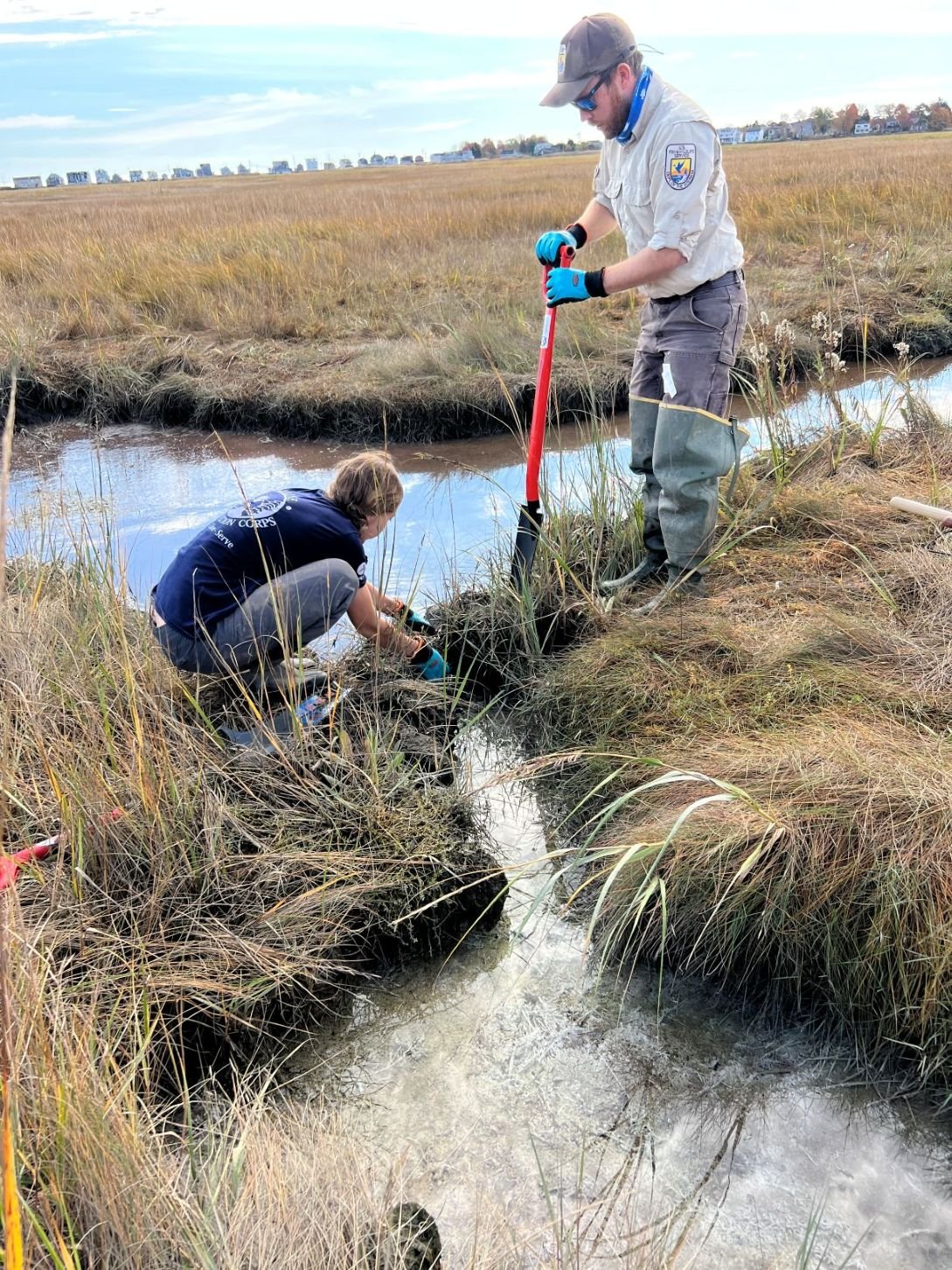
University of New Hampshire researchers and Ducks Unlimited measured the site’s topography using LIDAR to determine how much sand to spread in different areas. To improve drainage to the site, a berm was removed and small channels were dug. And, in order to protect the marsh from damage, the crews had to wait until the ground was frozen and, even then, used special mats to move across the surface. 

Photo courtesy of Bri Benvenuti/Ducks Unlimited

If the Wells pilot project is successful, Benvenuti hopes to see the technique used in other parts of the state and region. The project, which cost about a million dollars, is a collaboration between the town of Wells, Ducks Unlimited, the University of New Hampshire and state and federal agencies, and was funded by Greenfield Penobscot Estuary Beneficial Project Trust and two private foundations. Researchers from the University of New Hampshire are monitoring a host of factors including marsh elevation, hydrology, soil biogeochemistry, tidal bird abundance and salt marsh sparrow nesting.


Salt marsh sparrows are small, orange-cheeked birds with a call that sounds like radio static. They are salt marsh obligates, which means they can’t live anywhere else. They are so adapted to the rhythms of the tides that the bird’s entire reproductive cycle from nesting to fledging takes place between the highest tides of the month, when the marsh’s water levels are highest. The bird is an indicator species for salt marshes — a proxy for how well the marshes are faring overall.


And the indications aren’t good, said Adrienne Kovach, a professor in  UNH's department of natural resources and the environment, standing at the restoration site in the Wells marsh where researchers have been monitoring populations for years.


As sea levels rise, fewer young are surviving because their nests are flooded before the birds can fledge. The bird’s population has fallen by 90 percent over the last two decades. If nothing changes, salt marsh sparrows are projected to go extinct by 2050. 


In a portion of the marsh that includes the pilot project, researchers found nine nests this year. But six of the nests failed — the eggs in one were eaten by predators, but the others were taken by the rising water — either the eggs floated out of the nest or the hatchlings drowned.


Looking out across the expanse of sparkling white sand, Kovach said things were looking promising so far. She pointed out withered stalks of glasswort, a plant adapted to the wettest parts of the marsh. In the sandy zone, it was dry and dead. But outside the sandy spot, it was healthy.


This suggests that the spot where the sediment was spread was already dryer than surrounding areas. Project organizers hope that, within five years, the site will be fully revegetated with the species of grass that salt marsh sparrows use to nest and will flood only twice a month during the highest tides.


Pointing out a few blades of marsh grass poking through the crusty sand, Kovach said, “Hopefully in a year or few, it’ll look really different.”

banner that reads "on our radar"

This piece from National Geographic explores a new metric for measuring mountains: “It is essentially a method of quantifying grandeur, one that looks at 29,032-foot Mount Everest, does some arithmetic, and ranks the world’s ostensibly loftiest peak a paltry 46th.” And this story, from The Associated Press, looks at how female oyster farmers in coastal Ghana are working to save their livelihood as it's threatened by climate change.


Also: The Maine Monitor has a booth all weekend long at the Common Ground Country Fair in Unity. Maine Monitor environmental reporter Emmett Gartner will be speaking Saturday at 2 p.m. in the Yoga and Railcar Speakers Tent about climate resilience and how Maine's coastal communities are preparing for the rising seas and more frequent, intensifying storms brought on by climate change.

Meet The Maine Monitor at the Common Ground Fair from Sept. 19-21 and get your free tote (while supplies last).
banner that reads "in other maine environmental news"

While The Maine Monitor does not place its content behind paywalls, some newsrooms we link to in this newsletter may. 

'Unacceptable': Gov. Mills opposes Central Maine Power's request to hike electric rates | WMTW


New England hydropower generation slows amid drought | Maine Public


Maine’s forests, yards and lakes under siege by invasive species | Sun Journal


Electric aquaculture boats splash into waters off the coast of rural Maine | Daily Yonder & Canary Media


New England’s shrimp industry is struggling, with fishermen catching few in 2025 | Associated Press


Study: Maine's largest public water supplies are contaminated with hexavalent chromium | Maine Public


Drought now considered extreme in parts of Maine | Maine Public


Could the drought impact apple orchards? | WMTW


Maine regulators choose five renewable power developments for contracts | Maine Public


After two years some of Maine’s electric school buses remain parked | Kennebec Journal


UNE researchers build detection systems to help storm-battered communities | News Center Maine


EPA reaches agreement with Midcoast Regional Redevelopment Authority after foam spill | WGME


Penobscot Nation to reclaim 1,700 acres in rural Maine as tribe grows land holdings | Portland Press Herald


Maine Water and Maine Coast Heritage Trust partner to conserve 257 acres of open space | Saco Bay News


Purchase finalized for permanent conservation of Barnard Forest in Piscataquis County | Maine Public

Join The Maine Monitor for the next stop of our listening tour: September 25 at the Alfond Youth & Community Center in Waterville from 2:30 p.m. to 5 p.m.

Have feedback, a correction or know of something we should look into? Send it to our newsroom. You can also directly email editor Kate Cough: kate@themainemonitor.org.


The Maine Monitor is a publication of the Maine Center for Public Interest Reporting, an independent and nonpartisan nonprofit news organization that produces investigative journalism. We believe news is a public good and keep our news free to access. We have no paywall and do not charge for our newsletters. If you value the reporting we do for Maine, please consider making a donation! We cannot do this reporting without your support.

DONATE NOW
banner that states the maine monitor is part of the trust project, an international consortium of news organizations implementing transparency standards. tap to learn about the monitor's editorial standards.

Manage preferences | Update email address


Email Marketing by ActiveCampaign